
Rochedale lies about 25km south-east of the city of Brisbane and the area today is still a mixture of rural and residential land, although, with the development of the Rochedale Estates, the rural properties are disappearing fast. Originally, small farms covered the northern section and grew a diversity of market garden crops, while the southern section is still mainly residential and bushland. Photos below show a typical market garden farm in Rochedale and a residential street in Rochedale South.


After 1824, explorers often passed through the Rochedale area but settlement at Rochedale did not begin until around 1865, when the first settlers moved into the area to farm the rich soil. By the end of the nineteenth century, most of the area was dedicated to farming with most of the land owned by a few landholders who owned several large blocks, so the population was very small. The Roche family, the original pioneers, owned a large portion of Rochedale from 1868 and the Gardiner family at the turn of the century, owned nearly half the suburb of Rochedale South. In the early 1900's, market gardens became established in the region with tropical fruits and vegetables the major crops. In the early 1920s, these large estates were broken into small blocks, but they still continued to operate as farms. When the large Roche estate which extended along Rochedale Road from Ford Road to Priestdale Road, was broken up, still more farmers moved in to use the rich red soil.
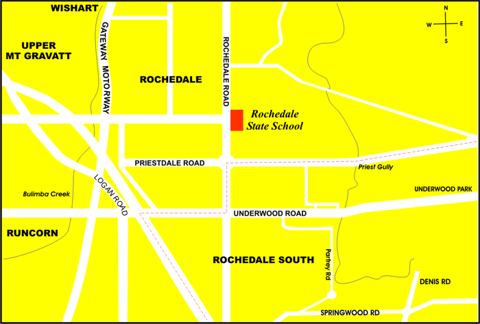
In 1931, Rochedale State School opened with 27 pupils. In 1965, the "Summit" estate offered 24 allotments on the higher part of the suburb. From then, the real estate developers followed in the farmers' path and the Rochedale area became covered in large residential estates, designed for young families moving out of the more populated inner suburbs. By 1973, three quarters of the population was under 35 and all the houses in the centre were only five years old. Rochedale grew fast until the mid nineties when from 1991 to 1996, the population actually fell from 1285 to 1252.
The Rochedale area today consists of the suburb of Rochedale which is part of Brisbane, and Rochedale South which is part of Logan City. The boundary of the two suburbs is the intersection of Priestdale and Rochedale Roads and Underwood Road.
The suburb of Rochedale South was officially gazetted in July, 1979. The suburb of Rochedale which was originally an area of market gardens and large estates with large private homes, is becoming closely populated, high denisty living, in the area between Gardiner Road and Rochedale Road. Rochedale South is also closely populated with some large but mostly smaller blocks. The larger blocks, in recent years, have been subdivided with 4 or 5 houses being built in close proximity on the one original block.
Many animals, birds and reptiles are still found in the Rochedale area, including possums, koalas, carpet snakes, flying foxes, echidna, foxes and wallabies. The Underwood Park complex has lagoons with many variety of wild fowl living on them.
In the 1981 Wildlife Survey, Rochedale recorded 94 species of birds of many types, eleven species of reptiles and seven species of native mammals. The photos below show some of the wild fowl living on one of the lagoons at Underwood Park, Rochedale South.
Click for a larger view


Bibliography:
Logan..The Man, The River and the City (Logan City Council)
Phil Reeves - Member for Mansfield
Logan City Library Local Studies Kits